
The boat ride took about an hour, and we got excited looked at the beautiful scenery. What would the next 8 days hold for us?

Day 1: Te Anau to Glade House, 5 km
Once we landed, we lined up to take a photo with the Milford Track sign. We were in Fiordland National Park (NP), a UNESCO World Heritage Site.

Then we hiked to the historic Glade House where we would spend the night.

After dropping off our packs we went for a nature walk. Cynthia felt ecstatic as we breathed in the fresh air and took in the scenery.

The Clinton River (and all the rivers here) are so clean that we could drink directly from them. The water from the river is also piped directly to Glade House.

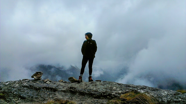
Day 2: Glade House to Pompolona Lodge - 16 km
We felt fortunate to have clear weather as we started hiking. The first thing we noticed was how green it was.

And how many different types of ferns there were.


We learned that these are Sundews, insectivorous plants that eat sand flies.

We got our first views of the beech forest and learned that would see three types of beech trees as we hiked: red (which the photo has), silver and mountain beech.

The Milford Track has mile markers, so we tried to take a photo of each one as we passed it.

We heard and saw lots of birds as we hiked, including the melodious tones of the New Zealand bellbird.

We also heard the tui and thought it was another bellbird until we saw it. We later heard from the guides that the tui mimics the calls of the bellbird. Since we didn't get a good photo, we're including this drawing so you can see its beautiful feathers.

This is a weka. It's also called a Māori hen.

Cynthia got this amazing photo of a weka looking right at her. The ones we saw in Milford were not shy and were quite curious about us.

This cute little puffball is a tomtit. Tomtits eat insects, and they frequently flew around the trail where we were hiking, hoping we would stir up some bugs.

Although we did see lots of birds on this first day, we also saw lots of traps like this one. The traps are to catch stoats, a non-native weasel that eats birds and their eggs, and has decimated the native bird populations of New Zealand.

We made our own sandwiches for lunch, so Kristina made a chicken-salad with carrots and beets.

It was a glorious day and we enjoyed ourselves immensely as we strolled through the rainforest.

Milford Track has abundant waterfalls as they get about 7 meters of rain annually over about 200 rain-days.

We appreciated the blue skies and how beautiful the scenery looked.

We chose a Milford Track hiking trip with Ultimate Hikes, who have an exclusive arrangement with the NZ Department of Conservation (DoC) to own and operate this tour. Ultimate Hikes and the DoC split the trail maintenance costs, including bringing in trestle bridges each season.

This photo shows elated hikers Pete and Cynthia arriving at Pompolona Lodge.

Day 3: Pompolona Lodge to Quintin Lodge via Mackinnon Pass - 15 km
The next morning after breakfast, the 45 guests and four guides assembled for a group photo. The three of us are on the right.

We set off for the big climb over Mackinnon Pass.

There was no rain at first, but the sky was overcast.

Kristina stood near this massive tree to show how large it was. Notice that she has her pack covered with a waterproof shell, in anticipation of rain.

At the mile 15 marker Pete and Cynthia made the Roman numerals XV with their poles.

As we hiked up it felt like entering the clouds.

The visibility decreased (although waterfalls are still visible behind Kristina and Cynthia) and the temperature dropped.

Mile marker 16 was near the top. We're wearing our hoods to keep our heads dry in the drizzle.

Cynthia is at the Quinton Mackinnon Memorial Cairn. In 1888 he found and surveyed the Milford Track, the first practical overland route on the South Island.

After about 100 meters more of climbing we reached the summit. Cynthia and Pete posed liked the intrepid hikers they were!

Here's a photo of our friend Marcelle taken at Mackinnon Pass in December of 2015. Marcelle shared her photos from Milford Track with us a few years ago, and ever since we've wanted to hike it ourselves.
After warming up and having lunch at a hut we started down the other side. These are Mountain Ribbonwood trees that grew as dwarf trees near the summit.

We set off for the big climb over Mackinnon Pass.

There was no rain at first, but the sky was overcast.

Kristina stood near this massive tree to show how large it was. Notice that she has her pack covered with a waterproof shell, in anticipation of rain.

At the mile 15 marker Pete and Cynthia made the Roman numerals XV with their poles.

As we hiked up it felt like entering the clouds.

The visibility decreased (although waterfalls are still visible behind Kristina and Cynthia) and the temperature dropped.

Mile marker 16 was near the top. We're wearing our hoods to keep our heads dry in the drizzle.

Cynthia is at the Quinton Mackinnon Memorial Cairn. In 1888 he found and surveyed the Milford Track, the first practical overland route on the South Island.

After about 100 meters more of climbing we reached the summit. Cynthia and Pete posed liked the intrepid hikers they were!

Here's a photo of our friend Marcelle taken at Mackinnon Pass in December of 2015. Marcelle shared her photos from Milford Track with us a few years ago, and ever since we've wanted to hike it ourselves.

After warming up and having lunch at a hut we started down the other side. These are Mountain Ribbonwood trees that grew as dwarf trees near the summit.

We were really glad to have hiking poles to help us with the descent.

It was rocky but luckily we didn't find the wet rocks too slippery.


The rain continued for most of the day.

This photo shows part of Margaret Falls, and how the water has carved beautiful deep, blue pools. We hiked down beside it for several kms.

And finally we arrived at Quintin Lodge and took hot showers. Ultimate Hikes does a great job with their comfortable lodges and tasty meals. We enjoyed having dinner with Hannah (right), her Dad Peter and their friend Craig from New South Wales, Australia.

Our guides seemed to enjoy their jobs, which includes being waiters in the evening. To serve dessert, each donned a costume to liven things up.

Day 4: Quintin Lodge - Mitre Peak Lodge via Sandfly Point - 21 km
We were up early again, as we had a long hike ahead of us. The next photos show the exterior of Quintin Lodge in its beautiful setting.


We had some muscle soreness but we felt empowered as we set off.


We had some muscle soreness but we felt empowered as we set off.

The rainforest trees grow with shallow roots, and they are vulnerable to tree avalanches, in which one tree brings down a whole swath of trees. Except for clearing trunks off the trail, the fallen trees are left in place to become "nurse logs" that will provide nutrients to future trees.

More rain today, but it wasn't continuous. Behind us is the Arthur River.

The rock wall on Cynthia's left had been dynamited to make the trail.

This is Sophie, one of our guides, at mile marker 32. We were close to the end by this point.

The Milford Track ends after 33.5 miles at Sandfly Point.

Day 5: Rest Day in Te Anau
No hiking today, but we had a great time on the Ultimate Hikes cruise on Milford Sound.

Technically it's a fjord, not of a sound, and it was stunningly beautiful.

We spotted a few fur seals sleeping on the rocks.
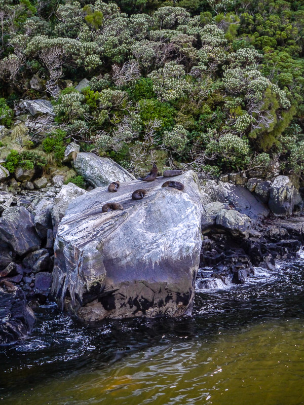
The boat went in for a closer look.

It had rained a lot in the previous days, so Stirling Falls and others had a lot of water in them.

The nose of our boat went right up to the falls, making for a loud and wet adventure.

We were fortunate to see it without rain, as Milford Sound is the wettest inhabited place in NZ and gets 6.5 meters of rain annually.

In Te Anau we took a walk. Kristina and Cynthia posed with a statue of Quintin McKinnon. He was a wee little man but his love of Milford Track was enormous.

We went to the Te Anau Bird Sanctuary to check out the endangered takahē. This breeding pair is raising a chick from an egg that had been taken from the wild.

Day 6: Te Anau/Divide to Lake Mackenzie - 13 km
The weather was clear when we started part two of our hiking trip: the Routeburn Track, starting in Fiordland NP and finishing in Mt Aspiring NP.

We had seen several New Zealand pigeons during our travels here. Finally Pete was able to get a good photo of one.

We noticed how different the scenery was here, much more alpine with long views.

We needed our sun hats.

And it was drier too. We were hiking east and ended up in the rain shadow.

The terrain was more varied on Routeburn too. Sometimes we scrambled up, but it didn't last that long.

We liked the look of these pineapple scrub plants.

And saw some whose leaves were turning red.

We spent the night at Mackenzie Lodge, and we noticed that the Routeburn lodges were even newer and nicer than Milford's.

Day 7: Lake Mackenzie to Routeburn Falls - 15 km
The next morning we hiked out to Lake Mackenzie for our group photo. This time we were 22 guests and three guides. The three of us are way in the back.

Our guides Rebecca and Moana had perfect poses for the photo.

"Burn" means river in Scottish, thus our Routeburn tramp was called river route. The green water peeking through the grasses is the Hollyford River.

We never got tired of looking at the views.

Our guides Rebecca and Moana had perfect poses for the photo.

"Burn" means river in Scottish, thus our Routeburn tramp was called river route. The green water peeking through the grasses is the Hollyford River.

We never got tired of looking at the views.


We stopped for a break atop this ridge. Behind us are the Darran Mountains across the Hollyford Valley.

All three of us loved the Routeburn Track. This photo shows down into the Hollyford Valley more clearly.

We were hiking above the tree line for most of the day.


This is Jason in the Harris Saddle hut. He's making tea for us to enjoy with our bagged lunches.

Pete was feeling spunky so he opted to hike up to Conical Hill. He left his pack at the lunch hut and set off with about a dozen other guests.

And here he is at the top, with the great view.

This is Nobi and Kohei from Japan, who were on their honeymoon. We wished them very happy lives together!

From above Pete was able to photograph the Harris Saddle and lunch hut.

Meanwhile Kristina and Cynthia took their time hiking down. We stopped awhile under the shade of some huge boulders.

With the drier environment we saw this vegetable that looked to us like coral, but in fact it's a species of cushion plant known as a vegetable sheep. Apparently when large, it can look like a sheep.

Day 8: Routeburn Falls to Routeburn Road - 10 km
To Pete's left is part of the Routeburn Valley floor that experienced a huge amount of rain one week, which knocked down all the trees.

Only the meadow grasses have thus far regrown. We think this is the north branch of the Routeburn River.

The water looks blue/green because there's copper in the rocks.


A few guests and guides opted for a swim, but the water was really cold so we skipped it.

We took our time looking for birds as we strolled. This is a rifleman, NZ's smallest endemic bird who lives in the high altitude beech forrest.

This South Island robin was very curious about Kristina's boots. Perhaps the round orange logo on the tongue looked like a berry, as the bird stayed on her foot and pecked at it for quite awhile.

We couldn't believe our ears when our guide identified the bird calls we heard as that of the New Zealand falcon. Called a kārearea by the Māori, it is thought there are only 3,000-5,000 breeding pairs left in the wild. We craned our necks and kept listening, and finally we saw one land near us.

We realized that there were flying lessons in progress because a few moments later a fledgling flew in, pushing the parent off its perch. The fledgling landed awkwardly on the tree trunk and seemed to struggle to hold on. The parent kept calling to the fledgling and eventually it took off. We were elated.

The New Zealand falcon is featured on the $20 note.

What an amazing hiking adventure! Here's our final photo in Mt Aspiring National Park.

Cynthia got this photo from the bus as we waited for the sheep to clear off the road.

The group stopped in Glenorchy to receive our group photos and certificates. With Pete are our awesome guides Rebecca, Jason and Moana.

Then we went to Lake Wanaka for a few days of R&R. It felt great to get out of our hiking clothes and to make salad for ourselves in our Airbnb.

We stayed in a garden apartment, and were offered hot house tomatoes from the garden.

We did a little shopping in Lake Wanaka, and Kristina and Cynthia both found sheep and possum wool hats. We learned that bushtail possums were brought to NZ in the 1880s to start a fur industry, but they soon escaped and started eating the local birds. Now the possums are being eradicated.

We went for Korean food and toasted how much fun our time together in NZ had been!

Next Cynthia flies back to Oakland while Pete and Kristina start a two week cycling trip on the South Island.