Our stop in Columbus was a practical one: we’d been driving for six hours and we wanted to get out of the car and rest for the night. On our way into the city, we checked out the Main Street Bridge.

Built as part of the Public Works Program to help the US recover from the Great Depression, the Main Street Bridge was completed in 1937. We liked how the bridge was angled and thought it looked quite modern.

Here’s the view of downtown Columbus from the bridge.

We still had a little time before nightfall, so we went to the University of Ohio campus and walked around.

There is an amazing natatorium there.

We watched the swim and dive meet going on for a little while. These divers were in a warm up period, but they were impressive!


The Thompson Library is incredible.

It was built by Gund Partnership with Acock Associates Architecture. This is one of the reading rooms.

The next day we visited the Cahokia Mounds near St Louis. This is the largest mound, and the three men walking were going to the top to make a music video at sunset. There’s a guitar in the case that the last man is carrying.

We watched the sun getting low in the sky from the top. You can see the St Louis Arch in this photo.

Then we climbed back down the mound.

The visitor center has interesting exhibits about the history of Cahokia, which was a highly evolved Native American city in the 13th century. This is a stone carving of a bird man.

This exhibit is a recreation of a burial site that archeologists found. The bird man is lying on a bed of shells in the shape of an eagle. The shells show evidence of trade with other Native American groups.

In its heyday, much of the Cahokia city was enclosed in a stockade to protect them from attack. Today part of the wall has been reconstructed.

Archeologists believe as many as 40,000 people lived here and in the surrounding area. By comparison, it was the largest city in North America until the 18th century when Philadelphia surpassed it.

Pete is peeking around a pole that is part of a calendar.

When standing in the center of the circle on the vernal and autumnal equinoxes, the sun rises right over this pole.

We drove next to Kansas City (KC) to stay with our dear friends Pat and Sarah (right). We didn’t know Sarah would be there, so we were doubly glad to see both of them! They gave us a tour of KC. We are pictured at the Liberty Memorial that honors WWI soldiers.

Pat and Sarah have a lovely house in San Francisco, and in the past Pete and Pat have made salami together. We had lots to catch up on.

The Liberty Memorial was built in an Egyptian Revival architectural style. This sphinx is made of limestone, and it is covering its eyes because WWI was so horrible.

This is the view we saw from the Liberty Memorial.

We knew we were in for a treat visiting Pat because she is an amazing cook. Pat fed us delicious barbecued duck breast, prosciutto and salami (right), all made by her!

This photo shows pickled cucumbers, carrots and beets that she also made.

Pat is working at Hallmark as a toy product manager, and she has a cool loft apartment in KC. This is the view from her window.

The next day Pat had to work, so Sarah took us on an extended tour. We had an authentic barbeque lunch at Oaklahoma Joe's BBQ.

Then we went to Pat and Sarah’s community garden.

Although the weather was predicted to turn cold, there were still salad greens and other vegetables to harvest.

It’s a sweet garden.


KC has so much public art. This Kenneth Snelson sculpture is called Triple Crown.

This is the Crying Giant located outside the Kemper Museum.

Hallmark is the largest company in KC, and the Hall brothers are huge art collectors. We visited the Donald J Hall Sculpture Park. Originally it had only Henry Moore sculptures like this one entitled Sheep Piece.


Now the sculpture park also includes other artists, such as Claes Oldenberg and Coosje van Bruggen who created Shuttlecocks. Each of their three sculptures is 17 feet tall.

This Roxy Paine sculpture is called Ferment.

We saw her incredible metal tree sculptures also in Seattle and Washington, DC.

All too soon we had to say good bye to Sarah and Pat. We drove to northern New Mexico, stopping in Clayton for the night. The weather had turned cold, and for most of the day the temperatures were below 30 degrees.

This was the second snow storm for us this season. The first storm was a small system that we drove through in western Pennsylvania. This was time it was much colder; It was 15 degrees Fahrenheit when we got into the car, brrr!

We went to the Bosque del Apache (BdA) wildlife preserve in New Mexico. It is a huge over-wintering spot for migratory birds. The first birds we saw in the preserve were hundreds of Snow Geese and Ross Geese.

The Ross Geese are almost entirely white except for black tips on their wings, while the Snow Geese have more black on them.


At BdA there are more than ten different types of ducks too. These are Northern Pintails. We also saw American Coots, Mallards and other ducks that we couldn't identify.

By diverting water from the Rio Grande, BdA becomes a seasonal wetland that provides food and shelter for thousands of migratory birds during the winter.

Here’s a Great Blue Heron hanging out in the above canal.

This is a Javelina or Collared Peccary. It looks like a small wild pig, but it’s a separate species that is native to the US.

The reason we came to BdA was to see the Sandhill Cranes. We found some in the late afternoon, hanging out in a marshy field. (There are two cranes in the foreground, and hundreds in the background of these photos.)


Around sunset, the cranes fly to a pond where they spend the night. By standing in water while they sleep, they can hear if predators are coming close.

We got up before sunrise to watch “the great fly off”. It was 20 degrees when we arrived, brrr!

First hundreds of geese flew in and landed on the pond. You can see their white feathers against the pond in this photo.

We had lots of company watching the birds!

Then the cranes started to wake up so we could see their heads and necks.

Next they started flapping their wings and stretching.

Then, in groups of about five, they started flying away.

In flight they are beautiful to watch!

The park rangers estimated there were about 4,000 cranes in the park while we were there. We drove in the direction the cranes had flown. This time we could get a bit closer to them.

Throughout the day we’d see a few cranes flying around, likely going to check out other places to eat.


BdA mows the fields in the preserve so that predators can't sneak up on the birds. These two cranes were hanging out and eating in a field. They had such bright red patches on their heads.

We left New Mexico and went north into Colorado. We enjoyed the scenery.


We spent a night in Pagosa Springs at a resort with wonderful outdoor soaking pools. Pete is in the Venetian pool that was 106 degrees, ahhh.

Located on the San Juan River, we liked looking at the view from the pools.

Pete even ventured into the river for a cold plunge at 47 degrees, brrr!

It had snowed the day before, so the palapas still had a dusting of white.

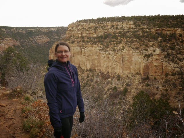
We drove to Mesa Verde, Colorado.

Kristina is in front of the visitor’s center, and you can see Mesa Verde National Park in the background. Mesa Verde is also a UNESCO World Heritage Site, our 11th heritage site to visit this year.

Because it’s late in the season only the Spruce Tree House was open for visitors.

Inhabited in the 13th century, the cliff dwellers farmed corn, beans and squash on the mesa above their homes.

This is a kiva that was used for religious ceremonies. It would have been covered with a roof.

Pete is climbing down into a reconstructed kiva.

And here’s a view of the interior. It was nice and warm inside.

After touring the Spruce Tree House we hiked the Petroglyph Trail.
The petroglyphs, carved artworks, are symbols for different tribes that lived in the area.

The hiking trail went through amazing boulders.

Steps like these made it easier to hike this terrain. The Native Americans who lived here must have been in great shape!


Next we went to Moab, Utah, and spent the night in an Airbnb. This is our windshield in the morning. It was 17 degrees, brrr!

Only trace amounts of snow remained in the high desert, but it looked beautiful next to the red sandstone.

We loved Arches National Park. This formation is called The Three Gossips.

The arches are formed by wind and water. Kristina's folks sent us a link to a fascinating article in the Financial Times that explains why sandstone erodes in this beautiful way.

This is Landscape Arch, with a span of 290 feet!


Kristina is in front of Double O arch. There was a much larger round arch above her.

We loved hiking in the wide open landscape that was filled with such interesting sandstone formations.


This one is named Balanced Rock. It's hard to tell from this photo, but it's the size of three school buses.

We hiked a short spur off the Devil's Garden trail to see Private Arch.

Delicate Arch is the symbol of the park. We added this sticker to the skybox on our car.


We have driven 17,760 miles on our road trip through the US and Canada. We feel fortunate that we didn’t have any issues for most of the trip. But when we got to Great Basin, Nevada, a deer ran across the road in front of us and we hit it. Luckily we weren’t hurt and neither was the deer - it went bounding away. We’ll have to have some bodywork done to our car.

As we crossed into California we stopped at Mono Lake. The photo shows that the water level is quite low, with the marker in front showing where how much higher the lake was in 1939.

These are tufa formations that used to be under water. Tufa is formed by hot springs in the lake bubbling up minerals like limestone and travertine.


We hiked around the nearby Panum Crater. Pete is next to part of the lava plug.

When this volcanic crater formed just 650 years ago, obsidian rock was created.

Lots of the rock near the crater is made of pumice, making it amazingly lightweight.

The colors of the desert were beautiful, with the stark hills in the background.

We drove up the Sonora Pass.

At elevations above 9,000 feet, there was enough snow for us to start thinking about skiing.

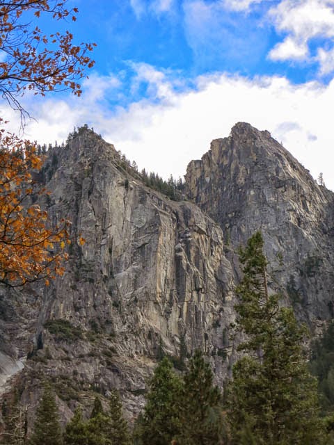
Our 18th and final National Park that we visited this year was Yosemite. In the past we have driven through Yosemite, but we've never stayed in the park nor hiked here until this visit. Yosemite wasn’t as cold as where we came from, and some of the trees still had their leaves.

We were awed by the sheer granite walls surrounding Yosemite Valley. This peak is called The Sentinel.

It is because of the efforts of John Muir and others that Yosemite National Park was created in 1864; The Yosemite Land Grant passed through Congress and was signed by Abraham Lincoln. These peaks are called the Three Brothers.

John Muir loved nature and often described it as his true home. He co-founded the Sierra Club to help preserve wilderness areas. This is El Capitan, rising 3,000 from the valley floor.

It was misty when we looked up at Half Dome from the valley floor.

Yosemite Valley has the Merced River meandering through it.

The views from the valley are wonderful.

We spotted this Coopers Hawk.

This time of year the waterfalls have very little water in them, but they are still quite loud due to the height of the falls.

It was nice to see some blue sky above the granite peaks.
We have had a wonderful time on our road trip! We will be in the Bay Area until Christmas when we head down to San Diego. We hope you have a wonderful holiday season! Our blog will resume in the new year.

Built as part of the Public Works Program to help the US recover from the Great Depression, the Main Street Bridge was completed in 1937. We liked how the bridge was angled and thought it looked quite modern.
Here’s the view of downtown Columbus from the bridge.
We still had a little time before nightfall, so we went to the University of Ohio campus and walked around.
There is an amazing natatorium there.
We watched the swim and dive meet going on for a little while. These divers were in a warm up period, but they were impressive!
The Thompson Library is incredible.
It was built by Gund Partnership with Acock Associates Architecture. This is one of the reading rooms.
The next day we visited the Cahokia Mounds near St Louis. This is the largest mound, and the three men walking were going to the top to make a music video at sunset. There’s a guitar in the case that the last man is carrying.
We watched the sun getting low in the sky from the top. You can see the St Louis Arch in this photo.
Then we climbed back down the mound.
The visitor center has interesting exhibits about the history of Cahokia, which was a highly evolved Native American city in the 13th century. This is a stone carving of a bird man.
This exhibit is a recreation of a burial site that archeologists found. The bird man is lying on a bed of shells in the shape of an eagle. The shells show evidence of trade with other Native American groups.
In its heyday, much of the Cahokia city was enclosed in a stockade to protect them from attack. Today part of the wall has been reconstructed.
Archeologists believe as many as 40,000 people lived here and in the surrounding area. By comparison, it was the largest city in North America until the 18th century when Philadelphia surpassed it.
Pete is peeking around a pole that is part of a calendar.
When standing in the center of the circle on the vernal and autumnal equinoxes, the sun rises right over this pole.
We drove next to Kansas City (KC) to stay with our dear friends Pat and Sarah (right). We didn’t know Sarah would be there, so we were doubly glad to see both of them! They gave us a tour of KC. We are pictured at the Liberty Memorial that honors WWI soldiers.
Pat and Sarah have a lovely house in San Francisco, and in the past Pete and Pat have made salami together. We had lots to catch up on.
The Liberty Memorial was built in an Egyptian Revival architectural style. This sphinx is made of limestone, and it is covering its eyes because WWI was so horrible.
This is the view we saw from the Liberty Memorial.
We knew we were in for a treat visiting Pat because she is an amazing cook. Pat fed us delicious barbecued duck breast, prosciutto and salami (right), all made by her!
This photo shows pickled cucumbers, carrots and beets that she also made.
Pat is working at Hallmark as a toy product manager, and she has a cool loft apartment in KC. This is the view from her window.
The next day Pat had to work, so Sarah took us on an extended tour. We had an authentic barbeque lunch at Oaklahoma Joe's BBQ.
Then we went to Pat and Sarah’s community garden.
Although the weather was predicted to turn cold, there were still salad greens and other vegetables to harvest.
It’s a sweet garden.
KC has so much public art. This Kenneth Snelson sculpture is called Triple Crown.
This is the Crying Giant located outside the Kemper Museum.
Hallmark is the largest company in KC, and the Hall brothers are huge art collectors. We visited the Donald J Hall Sculpture Park. Originally it had only Henry Moore sculptures like this one entitled Sheep Piece.
Now the sculpture park also includes other artists, such as Claes Oldenberg and Coosje van Bruggen who created Shuttlecocks. Each of their three sculptures is 17 feet tall.
This Roxy Paine sculpture is called Ferment.
We saw her incredible metal tree sculptures also in Seattle and Washington, DC.
All too soon we had to say good bye to Sarah and Pat. We drove to northern New Mexico, stopping in Clayton for the night. The weather had turned cold, and for most of the day the temperatures were below 30 degrees.
This was the second snow storm for us this season. The first storm was a small system that we drove through in western Pennsylvania. This was time it was much colder; It was 15 degrees Fahrenheit when we got into the car, brrr!
We went to the Bosque del Apache (BdA) wildlife preserve in New Mexico. It is a huge over-wintering spot for migratory birds. The first birds we saw in the preserve were hundreds of Snow Geese and Ross Geese.
The Ross Geese are almost entirely white except for black tips on their wings, while the Snow Geese have more black on them.
At BdA there are more than ten different types of ducks too. These are Northern Pintails. We also saw American Coots, Mallards and other ducks that we couldn't identify.
By diverting water from the Rio Grande, BdA becomes a seasonal wetland that provides food and shelter for thousands of migratory birds during the winter.
Here’s a Great Blue Heron hanging out in the above canal.
This is a Javelina or Collared Peccary. It looks like a small wild pig, but it’s a separate species that is native to the US.
The reason we came to BdA was to see the Sandhill Cranes. We found some in the late afternoon, hanging out in a marshy field. (There are two cranes in the foreground, and hundreds in the background of these photos.)
Around sunset, the cranes fly to a pond where they spend the night. By standing in water while they sleep, they can hear if predators are coming close.
We got up before sunrise to watch “the great fly off”. It was 20 degrees when we arrived, brrr!
First hundreds of geese flew in and landed on the pond. You can see their white feathers against the pond in this photo.
We had lots of company watching the birds!
Then the cranes started to wake up so we could see their heads and necks.
Next they started flapping their wings and stretching.
Then, in groups of about five, they started flying away.
In flight they are beautiful to watch!
The park rangers estimated there were about 4,000 cranes in the park while we were there. We drove in the direction the cranes had flown. This time we could get a bit closer to them.
Throughout the day we’d see a few cranes flying around, likely going to check out other places to eat.
BdA mows the fields in the preserve so that predators can't sneak up on the birds. These two cranes were hanging out and eating in a field. They had such bright red patches on their heads.
We left New Mexico and went north into Colorado. We enjoyed the scenery.
We spent a night in Pagosa Springs at a resort with wonderful outdoor soaking pools. Pete is in the Venetian pool that was 106 degrees, ahhh.
Located on the San Juan River, we liked looking at the view from the pools.
Pete even ventured into the river for a cold plunge at 47 degrees, brrr!
It had snowed the day before, so the palapas still had a dusting of white.
We drove to Mesa Verde, Colorado.
Kristina is in front of the visitor’s center, and you can see Mesa Verde National Park in the background. Mesa Verde is also a UNESCO World Heritage Site, our 11th heritage site to visit this year.
Because it’s late in the season only the Spruce Tree House was open for visitors.
Inhabited in the 13th century, the cliff dwellers farmed corn, beans and squash on the mesa above their homes.
This is a kiva that was used for religious ceremonies. It would have been covered with a roof.
Pete is climbing down into a reconstructed kiva.
And here’s a view of the interior. It was nice and warm inside.
After touring the Spruce Tree House we hiked the Petroglyph Trail.
The petroglyphs, carved artworks, are symbols for different tribes that lived in the area.
The hiking trail went through amazing boulders.
Steps like these made it easier to hike this terrain. The Native Americans who lived here must have been in great shape!
Next we went to Moab, Utah, and spent the night in an Airbnb. This is our windshield in the morning. It was 17 degrees, brrr!
Only trace amounts of snow remained in the high desert, but it looked beautiful next to the red sandstone.
We loved Arches National Park. This formation is called The Three Gossips.
The arches are formed by wind and water. Kristina's folks sent us a link to a fascinating article in the Financial Times that explains why sandstone erodes in this beautiful way.
This is Landscape Arch, with a span of 290 feet!
Kristina is in front of Double O arch. There was a much larger round arch above her.
We loved hiking in the wide open landscape that was filled with such interesting sandstone formations.
This one is named Balanced Rock. It's hard to tell from this photo, but it's the size of three school buses.
We hiked a short spur off the Devil's Garden trail to see Private Arch.
Delicate Arch is the symbol of the park. We added this sticker to the skybox on our car.
We have driven 17,760 miles on our road trip through the US and Canada. We feel fortunate that we didn’t have any issues for most of the trip. But when we got to Great Basin, Nevada, a deer ran across the road in front of us and we hit it. Luckily we weren’t hurt and neither was the deer - it went bounding away. We’ll have to have some bodywork done to our car.
As we crossed into California we stopped at Mono Lake. The photo shows that the water level is quite low, with the marker in front showing where how much higher the lake was in 1939.
These are tufa formations that used to be under water. Tufa is formed by hot springs in the lake bubbling up minerals like limestone and travertine.
We hiked around the nearby Panum Crater. Pete is next to part of the lava plug.
When this volcanic crater formed just 650 years ago, obsidian rock was created.
Lots of the rock near the crater is made of pumice, making it amazingly lightweight.
The colors of the desert were beautiful, with the stark hills in the background.
We drove up the Sonora Pass.
At elevations above 9,000 feet, there was enough snow for us to start thinking about skiing.
Our 18th and final National Park that we visited this year was Yosemite. In the past we have driven through Yosemite, but we've never stayed in the park nor hiked here until this visit. Yosemite wasn’t as cold as where we came from, and some of the trees still had their leaves.
We were awed by the sheer granite walls surrounding Yosemite Valley. This peak is called The Sentinel.
It is because of the efforts of John Muir and others that Yosemite National Park was created in 1864; The Yosemite Land Grant passed through Congress and was signed by Abraham Lincoln. These peaks are called the Three Brothers.
John Muir loved nature and often described it as his true home. He co-founded the Sierra Club to help preserve wilderness areas. This is El Capitan, rising 3,000 from the valley floor.
It was misty when we looked up at Half Dome from the valley floor.
Yosemite Valley has the Merced River meandering through it.
The views from the valley are wonderful.
We spotted this Coopers Hawk.
This time of year the waterfalls have very little water in them, but they are still quite loud due to the height of the falls.
It was nice to see some blue sky above the granite peaks.
We have had a wonderful time on our road trip! We will be in the Bay Area until Christmas when we head down to San Diego. We hope you have a wonderful holiday season! Our blog will resume in the new year.