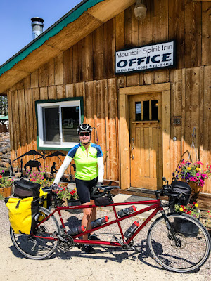
Day 1: Missoula to Darby 115 km, 600 m
It was forecasted to be a heatwave so we got an early start, heading out of Missoula on the Bitterroot Bike Path.

Pete fueled up with cold-brewed coffee in Lolo at the Florence Coffee Company coffee shack.

A few hours later we stopped for another snack. When Pete was little his nickname was Bobo, so he tried Bobo's, a pretty tasty energy bar.

As forecasted, it was a hot day of riding. When we arrived at our hotel in Darby, we were ready for a cool shower.
We walked around the tiny town.

We saw many signs in Montana in the shape of the state. We were in the Bitterroot Valley, named for the edible plant that the Native Americans harvested.

The Bitterroot Valley is surrounded by the Bitterroot Mountains, and the National Forest has the same name too.

It wasn't the season for the Bitterroot to bloom, but we saw a postcard with Montana's pretty state flower in the Darby Ranger Station.

Day 2: Darby to Jackson 120 km, 1,45 m

Pete thought it might be fun to drive a tractor.

As we rode the last 30 kms to Jackson we saw touring cyclists on a Trans-America route. An extra bonus of this road is that it includes Lewis and Clarke's 1805-06 expedition route too.

When we arrived in Jackson we met six cyclists riding the Trans-Am. This is Cathy from San Luis Obispo.

Jackson was even smaller than Wisdom. We stayed in the only hotel in town, the Jackson Bunkhouse. It's also the post office.

The Bunkhouse was charming, with red paint and western themes throughout.

Day 3: Jackson to Wise River 102 km, 1,230 m

But Kristina had another idea. She had spotted this cute little utility terrain vehicle (UTV) with its mounted bullhorns hood ornament and thought we should take it for a spin.

Pete prevailed and we set off on the tandem. We spotted several beaver slides near the road. Beaver slides had been the preferred way to make big haystacks in the past.

But we saw a few haystacks that were probably still made the old-fashioned way.

We stopped for a snack at a pullout on the Pioneer Mountains Scenic Byway.

A few minutes later we were joined by some Continental Divide riders.

Alan and Cindy are Canadians who are riding the Divide from Banff, BC to New Mexico. They are camping, and at points they will have to carry enough water and food for four days. We were impressed! Did we mention the Divide is mostly off-road?

We wished them well, and rode on. Next we stopped at a historic site marker.

There were signs with information about the Big Hole Valley. Pete is next to a beaver slide.

One exhibit had a moving letter of Captain Meriwether Lewis from the Lewis and Clarke Expedition, in which he realizes his past selfishness and vows to live for mankind.

As we continued we came upon a trio of Sandhill Cranes, a couple and their colt.

We love riding on scenic byways!


We stopped for a simple picnic lunch at the Little Joe Campground.

It was great to ride near a river, and to feel its cooling influence on the air temperature.


We weren't surprised to see that fire danger was rated extreme, and we had been checking on several local wildfires that had been started by lightning.

We rolled into Wise River in the early afternoon. Wise River is tiny, so we didn't have much choice about where to eat.

The exterior of the Wise River Club had plenty of atmosphere.

They served hearty fare. Pete devoured a ribeye steak, potatoes, and green beans.

Kristina ate a large salad with salmon.

We went back a little later for pie.

As we left the restaurant, we noticed a lot of smoke in the air.

After calling our next two accommodations, we decided we should alter our route and ride back to Missoula the way we came, so as to avoid as much smoke from the forest fires as possible.

Day 4 Wise River to Jackson 91 km with 564 m

We spotted these beautiful horses just off the side of the road. As we approached to take a photo, they started galloping away.

Kristina wore a camel back, to ensure we'd have enough water as we rode.

This overlook had a nice view of the river and valley.

We think this is a Golden Eagle. It was a very large bird.

Here a mama Osprey (right) is trying to coax her fledglings out of the nest.

Around 1 pm we rolled back into Wisdom.

We were hungry so we went to The Crossing for lunch.

We locked up our bike on their hitching post.

The Crossing started in 1932 as Fetty's, and we were glad this institution was still in business.

With such a big dessert board it was hard to choose.

We went for rhubarb pie, which was excellent.

The Big Hole Valley is also know for cattle.

Kristina tried to take a photo of this herd, but they got spooked and ran away with lots of mooing.

Day 5 Jackson to Darby, 123 km with 719 m

As we rode we had views of the Big Hole Valley, this time with more smoke in the air.

The wooden gates in the high plains are really cool looking.

It was cold as we started out, just a bit over freezing (3 degrees celsius). After 8 km we stopped to let Pete warm up his hands. The sun was starting to warm up the valley, and it got more comfortable to ride.

We saw a sleeping magpie, a Redtail Hawk and more Sandhill Cranes close up.

We stopped at the Big Hole National Battlefield and learned more about the tragic battle with the Nimiipuu (Nez Perce).


There we met Eric from Denmark. He was about to pass his personal longest cycling tour of 6,400 km. He was riding the Trans Am and will ultimately ride 8,400 kms.

We could see evidence of Mountain Pine Beetle damage, perhaps a third of the trees were dead in spots.

We rode back into Darby. This is their fire station.

Day 6 Darby to Missoula 110 km, 375 m

Here's a close up of their cool sign.

As we rode out of town, we saw this beautiful metal sculptured entitled Double Stud.

And this piece entitled Darbacious by the artist Michael Miller. It's constructed of old barbed wire.

We met another tandem-touring couple, Vickie and Dan from Denver, on the Bitterroot Trail. They were completing a Vancouver, BC to Denver trip.

As we headed north the skies became more hazy with the smoke from nearby fires.

Here we are at the beginning of the Bitterroot Trail, where we had started six days earlier.

We headed straight to lunch at Tia's Big Sky restaurant.

We enjoyed a delicious lunch of tacos, coleslaw, pickles and drinks.

Our totals for the tour were 660 km and 4,973 m, with an average day of 110 km and 829 m. Here's a map of our route. We rode the route shown in red. The route shown in purple is the part of the route we couldn't ride due to the forest fires. (If you don't see the map, click here.)
We were glad to have a few days after the tour to relax in Missoula. Missoula is known as The Garden City.

We explored a few neighborhoods, and saw some beautiful flower gardens.

Not surprisingly we saw Bitterroot flower decorations in Missoula.

We stayed in The Hip Strip, an older part of Missoula, south of the Clark Fork River.

We crossed the river to go down town. From the bridge we could see people kayaking and surfing in the river break.

Early the next morning we took a walk. From across the river we could see the natural history museum called the Boone and Crocket Club and the river break.

We learned that the river break had been built as a memorial to a world-class local kayaker named Brennan Guth who had died in a kayaking accident in Chile. It's called Brennan's Wave.

We went to the Missoula Art Museum and enjoyed the exhibit of Chris Pappan's ledger artworks. This is Mind the Gap.

Outside the museum was a bike sculpture entitled Only One Hiawatha by Anne Appleby and Kim Reineking.

We went by the Adventure Cycling Association, but the office was closed. Note the bike handlebars as door handles!

This is the Bluebird Building, one of the oldest in Missoula.

The St Francis Xavier Catholic Church was built in 1892.

We tried Sweet Peaks ice cream and were very satisfied with their rich and creamy flavors.

The Wilma Theater, built in 1921, is still hosting shows.

We left Missoula and headed into Idaho. We had stayed at the Challis Hot Springs last year on a cycling tour around Idaho, so we were looking forward to going back and soaking.

The next day we took a hike along French Creek.

By the creek it was lush and green.

We drove to Boise and stayed for a few days. Here's Kristina in front of our small but comfortable Airbnb house in Boise's historic North End neighborhood.

We took a ride up to Bogus Basin. We saw that the bike way was named for three-time Olympic time trial champion Kristen Armstrong.

Bogus Basin is a winter ski resort, and they were offering some summer mountain biking options too.

Then we cruised back down, away from the National Forest Land and into Boise.

Although Boise is mostly an area of high desert, the tree-lined Boise River Valley was called “La Riviere Boise” by the French trappers, which means “wooded river.” Boise is now called The City of Trees, and we saw many mature, beautiful trees in the North End where we stayed.

Each day we walked around the North End, enjoying all the Victorian and Craftsman-style homes. We learned that Boise had boomed between 1900-1920, resulting in these charming cottages being built in the North End.

We noticed a contemporary detail of painting the wooden shingles on the cottage walls in decorative colors.

What a cute porch! Note the Idaho state shape "o" in home.

We came across Freak Alley, which is covered in murals.

The murals were first painted in 2002, and now there's an annual week long mural painting party in August to freshen up the murals and add new ones. We especially liked the use of tile in this piece.

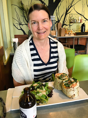
We went to Wild Root for lunch. Pete ordered the avocado bahn mi with candied pork belly.

Kristina got the Indian flatbread wrap with salmon. Both were really yummy.
All around the North End we saw people riding bikes. Boise Bicycle Project seems very active, and they were promoting their bike parade coming up this weekend.

Another day we rode along the river on the Boise River Greenbelt Trail, a great 23 km bike path. We rode out to Lucky Peak Dam (that's it with the Keep Your Forests Green sign), below which is a Boise-style beach and recreation area.

Above the Boise River were these amazing volcanic rocks formations. We learned that the Boise Valley was called Peace Valley by four Native American tribes who came together to trade in the valley.

The Boise River Greenbelt Trail crossed the river as we got back into town. Behind Pete are two people floating on the river to stay cool as they fish. Boise is a pretty sweet place!

Next we head to Colorado.

Pete fueled up with cold-brewed coffee in Lolo at the Florence Coffee Company coffee shack.

A few hours later we stopped for another snack. When Pete was little his nickname was Bobo, so he tried Bobo's, a pretty tasty energy bar.

As forecasted, it was a hot day of riding. When we arrived at our hotel in Darby, we were ready for a cool shower.

We walked around the tiny town.

We saw many signs in Montana in the shape of the state. We were in the Bitterroot Valley, named for the edible plant that the Native Americans harvested.

The Bitterroot Valley is surrounded by the Bitterroot Mountains, and the National Forest has the same name too.

It wasn't the season for the Bitterroot to bloom, but we saw a postcard with Montana's pretty state flower in the Darby Ranger Station.

Day 2: Darby to Jackson 120 km, 1,45 m
We started riding early again, at about 7 am and the temperature was nice and cool. We stopped to look at an Osprey at the top of a tree. It took off just as Pete took the photo.

We had a challenging climb this day, up to Chief Joseph Pass. We stopped to rest and enjoy the view a number of times.

This is the Lost Hills Ski Resort.

It got cooler as we climbed and we reached the 2,200 meter summit about noon.

Behind Kristina is a sign for Chief Joseph Pass and the Continental Divide.

It was fun to ride down the other side! When the road flattened out we were in high plains called the Big Hole Valley of 10,000 Haystacks. We noticed that these days the hay is typically rolled into tootsie roll shaped bales.

This truck had a wide load of hay bales.

We saw all stages of hay: growing, being cut, curing in the field. These hay bales were still scattered around the field where they had been baled.

We rode into the tiny town of Wisdom and were happy their only store was open.

Pete thought it might be fun to drive a tractor.

As we rode the last 30 kms to Jackson we saw touring cyclists on a Trans-America route. An extra bonus of this road is that it includes Lewis and Clarke's 1805-06 expedition route too.

When we arrived in Jackson we met six cyclists riding the Trans-Am. This is Cathy from San Luis Obispo.

Jackson was even smaller than Wisdom. We stayed in the only hotel in town, the Jackson Bunkhouse. It's also the post office.

The Bunkhouse was charming, with red paint and western themes throughout.

Day 3: Jackson to Wise River 102 km, 1,230 m
Here's Pete in front of the Bunkhouse Hotel, ready to start riding.

But Kristina had another idea. She had spotted this cute little utility terrain vehicle (UTV) with its mounted bullhorns hood ornament and thought we should take it for a spin.

Pete prevailed and we set off on the tandem. We spotted several beaver slides near the road. Beaver slides had been the preferred way to make big haystacks in the past.

But we saw a few haystacks that were probably still made the old-fashioned way.
We stopped for a snack at a pullout on the Pioneer Mountains Scenic Byway.

A few minutes later we were joined by some Continental Divide riders.

Alan and Cindy are Canadians who are riding the Divide from Banff, BC to New Mexico. They are camping, and at points they will have to carry enough water and food for four days. We were impressed! Did we mention the Divide is mostly off-road?

We wished them well, and rode on. Next we stopped at a historic site marker.

There were signs with information about the Big Hole Valley. Pete is next to a beaver slide.

One exhibit had a moving letter of Captain Meriwether Lewis from the Lewis and Clarke Expedition, in which he realizes his past selfishness and vows to live for mankind.

As we continued we came upon a trio of Sandhill Cranes, a couple and their colt.

We love riding on scenic byways!


We stopped for a simple picnic lunch at the Little Joe Campground.

It was great to ride near a river, and to feel its cooling influence on the air temperature.


We weren't surprised to see that fire danger was rated extreme, and we had been checking on several local wildfires that had been started by lightning.

We rolled into Wise River in the early afternoon. Wise River is tiny, so we didn't have much choice about where to eat.

The exterior of the Wise River Club had plenty of atmosphere.

They served hearty fare. Pete devoured a ribeye steak, potatoes, and green beans.

Kristina ate a large salad with salmon.

We went back a little later for pie.

As we left the restaurant, we noticed a lot of smoke in the air.

After calling our next two accommodations, we decided we should alter our route and ride back to Missoula the way we came, so as to avoid as much smoke from the forest fires as possible.

Day 4 Wise River to Jackson 91 km with 564 m
The next morning the air quality had improved.

So we got an early start and opted for a slightly different route to Wisdom.

Our route followed the course of the Big Hole River.

So we got an early start and opted for a slightly different route to Wisdom.

Our route followed the course of the Big Hole River.

We spotted these beautiful horses just off the side of the road. As we approached to take a photo, they started galloping away.

Kristina wore a camel back, to ensure we'd have enough water as we rode.

This overlook had a nice view of the river and valley.

We think this is a Golden Eagle. It was a very large bird.

Here a mama Osprey (right) is trying to coax her fledglings out of the nest.

Around 1 pm we rolled back into Wisdom.

We were hungry so we went to The Crossing for lunch.

We locked up our bike on their hitching post.

The Crossing started in 1932 as Fetty's, and we were glad this institution was still in business.

With such a big dessert board it was hard to choose.

We went for rhubarb pie, which was excellent.

The Big Hole Valley is also know for cattle.

Kristina tried to take a photo of this herd, but they got spooked and ran away with lots of mooing.

Day 5 Jackson to Darby, 123 km with 719 m
Back in Jackson we met Kate from Michigan who was camping at the Bunkhouse. She had previously hiked the Appalachia Trail (in two stages) and the Pacific Crest Trail (in one go), and was now hiking the Divide Trail to earn her triple crown. Her trail name is Salt Lick.

As we rode we had views of the Big Hole Valley, this time with more smoke in the air.

The wooden gates in the high plains are really cool looking.

It was cold as we started out, just a bit over freezing (3 degrees celsius). After 8 km we stopped to let Pete warm up his hands. The sun was starting to warm up the valley, and it got more comfortable to ride.

We saw a sleeping magpie, a Redtail Hawk and more Sandhill Cranes close up.

We stopped at the Big Hole National Battlefield and learned more about the tragic battle with the Nimiipuu (Nez Perce).


There we met Eric from Denmark. He was about to pass his personal longest cycling tour of 6,400 km. He was riding the Trans Am and will ultimately ride 8,400 kms.

We could see evidence of Mountain Pine Beetle damage, perhaps a third of the trees were dead in spots.

We rode back into Darby. This is their fire station.

Day 6 Darby to Missoula 110 km, 375 m
We had a yummy blueberry oatmeal & egg breakfast at the Montana Café.

Here's a close up of their cool sign.

As we rode out of town, we saw this beautiful metal sculptured entitled Double Stud.

And this piece entitled Darbacious by the artist Michael Miller. It's constructed of old barbed wire.

We met another tandem-touring couple, Vickie and Dan from Denver, on the Bitterroot Trail. They were completing a Vancouver, BC to Denver trip.

As we headed north the skies became more hazy with the smoke from nearby fires.

Here we are at the beginning of the Bitterroot Trail, where we had started six days earlier.

We headed straight to lunch at Tia's Big Sky restaurant.

We enjoyed a delicious lunch of tacos, coleslaw, pickles and drinks.

Our totals for the tour were 660 km and 4,973 m, with an average day of 110 km and 829 m. Here's a map of our route. We rode the route shown in red. The route shown in purple is the part of the route we couldn't ride due to the forest fires. (If you don't see the map, click here.)
We were glad to have a few days after the tour to relax in Missoula. Missoula is known as The Garden City.

We explored a few neighborhoods, and saw some beautiful flower gardens.

Not surprisingly we saw Bitterroot flower decorations in Missoula.

We stayed in The Hip Strip, an older part of Missoula, south of the Clark Fork River.

We crossed the river to go down town. From the bridge we could see people kayaking and surfing in the river break.

Early the next morning we took a walk. From across the river we could see the natural history museum called the Boone and Crocket Club and the river break.

We learned that the river break had been built as a memorial to a world-class local kayaker named Brennan Guth who had died in a kayaking accident in Chile. It's called Brennan's Wave.

We went to the Missoula Art Museum and enjoyed the exhibit of Chris Pappan's ledger artworks. This is Mind the Gap.

Outside the museum was a bike sculpture entitled Only One Hiawatha by Anne Appleby and Kim Reineking.

We went by the Adventure Cycling Association, but the office was closed. Note the bike handlebars as door handles!

This is the Bluebird Building, one of the oldest in Missoula.

The St Francis Xavier Catholic Church was built in 1892.

We tried Sweet Peaks ice cream and were very satisfied with their rich and creamy flavors.

The Wilma Theater, built in 1921, is still hosting shows.

We left Missoula and headed into Idaho. We had stayed at the Challis Hot Springs last year on a cycling tour around Idaho, so we were looking forward to going back and soaking.

The next day we took a hike along French Creek.

By the creek it was lush and green.

We drove to Boise and stayed for a few days. Here's Kristina in front of our small but comfortable Airbnb house in Boise's historic North End neighborhood.

We took a ride up to Bogus Basin. We saw that the bike way was named for three-time Olympic time trial champion Kristen Armstrong.

Bogus Basin is a winter ski resort, and they were offering some summer mountain biking options too.

Then we cruised back down, away from the National Forest Land and into Boise.

Although Boise is mostly an area of high desert, the tree-lined Boise River Valley was called “La Riviere Boise” by the French trappers, which means “wooded river.” Boise is now called The City of Trees, and we saw many mature, beautiful trees in the North End where we stayed.

Each day we walked around the North End, enjoying all the Victorian and Craftsman-style homes. We learned that Boise had boomed between 1900-1920, resulting in these charming cottages being built in the North End.

We noticed a contemporary detail of painting the wooden shingles on the cottage walls in decorative colors.

What a cute porch! Note the Idaho state shape "o" in home.

We came across Freak Alley, which is covered in murals.

The murals were first painted in 2002, and now there's an annual week long mural painting party in August to freshen up the murals and add new ones. We especially liked the use of tile in this piece.

We went to Wild Root for lunch. Pete ordered the avocado bahn mi with candied pork belly.

Kristina got the Indian flatbread wrap with salmon. Both were really yummy.

All around the North End we saw people riding bikes. Boise Bicycle Project seems very active, and they were promoting their bike parade coming up this weekend.

Another day we rode along the river on the Boise River Greenbelt Trail, a great 23 km bike path. We rode out to Lucky Peak Dam (that's it with the Keep Your Forests Green sign), below which is a Boise-style beach and recreation area.

Above the Boise River were these amazing volcanic rocks formations. We learned that the Boise Valley was called Peace Valley by four Native American tribes who came together to trade in the valley.

The Boise River Greenbelt Trail crossed the river as we got back into town. Behind Pete are two people floating on the river to stay cool as they fish. Boise is a pretty sweet place!

Next we head to Colorado.