
Finally, nine months later, it was time for our trip and we felt scared and excited. The first morning we had to be on the bus at 4:30 am. Kristina took advantage of the two hour bus ride to get some extra sleep.

At the start of the hike we met the Llama Path team who would carry most of our gear for the four day hike. There were 14 porters, two cooks and two guides.

Here we are with our fellow hikers, a couple from Australia and three other couples from the US, a friendly and fun group of ten.

We started off along the Urubamba River. Kristina has her walking poles and a day pack with water and rain gear.

We had to book our tour so far in advance because only 200 people (including porters) are allowed to start hiking the Inca Trail each day. Kristina has her passport in hand after having cleared the checkpoint.

As we crossed the bridge over the Urubamba our trek felt real.

After walking for an hour we stopped to take a break. This cat liked Pete and was eager to get on his lap.

This is Patallacta, an Incan city with agricultural terraces. Like all the cities we would see, it was built during the 100 years that the Incas were at their peak, 1438-1533.

Our view was from the watch tower area above the city. Pete hiked with his camera out so he could take lots of photos.

Here's a panorama to give you a sense of the Andes mountains and valley around Patallacta.

Between 1438 and 1533 many Incan cities were built between Ecuador to Chile, along with 40,000 kms of known stone trails.

One of our guides named Michael showed us the Inca Trail route we would take over the next four days.

We stopped at Hatunchaca, a small village along the way. The day was warm and we enjoyed the gentle slopes and interesting views as we hiked.

The first day we hiked 16 kms and climbed 510 meters up to Ayapata. When we arrived the Llama Path team had already set up our tents. They gave us each a basin with hot water so we could wash up.

The second day was our hardest so we started hiking at 6 am. The trail went up and up and up.

We chewed coca leaves with lime to keep our heart rates from getting too high.

We hiked slowly and steadily, climbing up to 4,250 meters.

Here we are at Dead Woman's Pass, the highest peak on our four day hike. It was cold and windy at the top so we didn't linger.

As we went down the other side, it started raining pretty hard. We put on our rain ponchos.

This panorama shows the trail curving down.

After about 30 minutes the rain let up, but the stone trail remained wet and slippery.

The rain brought out the colors in the plants and flowers.


As we hiked it was fun to come across Incan stone buildings and to see what master stoneworkers they were. The walls withstood many earthquakes, but have also been repaired using the original mortar techniques.

At this site we were also impressed with the white granite stones appearing in the landscape.

We hiked two hours down. Here the huge granite boulders were over the trail.
Below Kristina is an oval building that is believed to have been a place for Incan messengers to rest after running the Inca Trail to deliver their oral messages. Quechua was the official language of the Incan Empire. When the Spanish finally conquered the Incas in 1572 they allowed them to continue speaking Quechua and even translated the Catholic texts into Quechua in order to convert them.

An upside of the rain was seeing a rainbow.

These little pink mushrooms were getting plenty of moisture, as the rainy season was starting.

It was a long day because we climbed 900 meters over 12 kms. We camped at Chaquicocha. The weather was constantly changing, and we liked watching the wispy clouds creeping over the peaks.

On the third day we started hiking at 6:30 am. Our guides joked that we were on the part of the trail that was "Peruvian flat".

We started seeing survey markers for Machu Picchu and knew we were getting closer to the incredible ancient city.

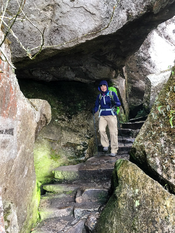
These granite boulders formed a cave that we climbed through.

It was quite foggy, but we got to see some domesticated llamas and alpacas. These animals have no trouble on the steep, rocky terrain.

We climbed down our third pass. Kristina slowly made her way down the steep, wet steps.

We were passed by the Llama Path porters carrying huge packs.

They are expert hikers and practically run down the trail. Here's a link to a short video of them in action.

Before lunch we arrived at Puyupatamarka City.

We climbed up and down the stairs, checking out the lower terraces and homes and the temple at the top.

The misty weather gave the place an air of mystery.

The Incas were master builders who tilted the walls back onto the hillside and offset the rocks to make the walls more durable.

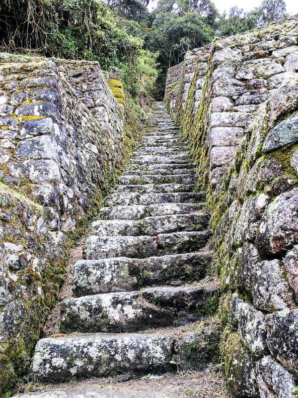
After walking up these steep stairs we were breathing hard.
When the clouds cleared we could see the river valley far below.

The three niches were perhaps used to make offerings to the gods of corn and potatoes.

These terraces support the stone buildings up the hill and also serve as agricultural terraces. The dark stones in the walls acted like solar heaters for the crops.

These Puyupatamarka buildings were likely houses.

It was interesting to see how close to the jungle the city was.

Above Kristina in the blue poncho was one of the gardeners working to keep the vegetation from covering up the walls.

We're not sure of the purpose of this building, but it has the classic Incan window structure that narrows at the top and has a wide lintel for support.

This image tries to show all the terraces. It was really impressive.

We camped near Wiñay Wayna and this was our view from the tent looking up at Puyupatamarka.

We hiked just 9km on our third day with 196 flights of stairs, a much easier day. We got the afternoon off so we went looking at the cloud forest flowers. There were begonias.

These are cantutas, the sacred flower of the Incas. They appear to be related to fuchsias.

We also saw lots of epiphytes.

After our rest we went to tour nearby Wiñay Wayna, another Incan city.

These are the houses of the city. Wiñay Wayna was also built during the heyday of the Incas in the 15th century.

How about this impressive wall?!

We learned that all these terraces were used in part to grow food for the people who lived at Machu Picchu.

We hiked up to the top to see the temple.

Here are our guides Michael (left) and Silvio. They told us that Wiñay Wayna was only 1/10th the size of Machu Picchu, and we were amazed.

Our group listened to Silvio who told us about Wiñay Wayna, including that the name means forever young because orchids bloom year round here. It was rediscovered in 1842 by a Peruvian archeologist.

Here's a panorama shot of the Rainbow Temple. It has seven windows that correspond to the seven colors of the rainbow.

This photo shows the Rainbow Temple from below. If you look closely you can spot Kristina flashing a peace sign over one of the walls.

This is a closer look at one of the houses.

Another section of windows in the house had partially collapsed, showing how the buildings are vulnerable to time and the elements.

Begonias were growing out of the walls.

It had rained earlier, and a few drops were still clinging to the flower.

There was a small herd of llamas at Wiñay Wayna so we took a bunch of photos of these cute animals.

The littlest llama started running back and forth on the terraces, and pretty soon all the llamas had joined in.

This llama thought we were getting too close, so he chased us up the stairs.

Back at our campsite we gathered in the meal tent. At night this was where the porters slept.

The food was excellent and creatively prepared. The cucumber bird looks over the causolimania, a Lima dish of mashed potatoes with lemon stuffed with chicken that was very tasty.

We were happy to have sautéed vegetables. Here an orange has been turned into a pig as a garnish.

Pete celebrated his 51st birthday on the Inca Trail. Chef Cesar made him a birthday cake!


We received Llama Path t-shirts that showed the route of our four day pilgrimage to Machu Picchu.

On our final morning of the trek we got up at 3 am so we could hike into Machu Picchu at dawn. It was raining with poor visibility when we arrived at the Sun Gate at 7:30.

Silvio explained that this large stone was used to sacrifice llamas to their gods.

We hiked another hour and then we were inside Machu Picchu.

Slowly the clouds started to clear, revealing the enormous summer residence of the Inca royal family.

It was cold but we were so excited to be at Machu Picchu!

This is Intihuatana, the Sun Temple. It was built with two high windows, such that at dawn on the solstice, the sun shines through one window.

And here's the view of the Sun Temple from above. The sun shines onto a chiseled crack on the large rock during the solstice. The Incan King Pachacuti was believed to be a direct descendent of the sun and this was probably his tomb.

Hayden (left) is listening to Silvio tell us about the Three Window Temple we would visit next.

In front of the three windows was a zigzag shaped stone known as the Andean Cross.

The Incan temples were made of polished dry-stone (without mortar) blocks that fit together so well that a knife could not be fitted through the stonework. Some of the stone blocks were so massive it was hard to imagine how they could have been moved into place, especially without the benefit of beasts of burden.

The right side of this temple had started collapsing in the early 20th century.

Up top was this sun dial stone.

Although a lot of the rebuilding that started in the 1970s has been completed, there will probably always be more that needs to be done. As we hiked down we spotted a few sections that were braced.

Through this window we could see another wall with a window and through it yet another wall. The size of Macchu Picchu was incredible.

Pete admired this classic Inca doorway that narrows at the top and has a larger lintel as a header stone.

This felt like a 'danger selfie' but we couldn't resist getting close to the edge to see the Urubamba River.

This is the Temple of the Condor, with its wings made of enormous granite boulders.

Hiram Bingham rediscovered Machu Picchu in 1911. It became a UNESCO World Heritage Site in 1983, and in 2007 it became one of the seven wonders of the world.

These days about five thousand people visit Machu Picchu daily.

This image shows the quarry of white granite in the lower left, which made it possible to build Machu Picchu.

Machu Picchu was like the puzzle we completed nine months ago, and also so much more impressive. It's hard to capture the scale of it in photos.

During our four days on the Inca Trail we hiked a total of 55 kms with a total elevation gain of 1,900 meters. Our legs were really tired so we ate some delicious Peruviano chocolate. We liked that it had the Machu Picchu brand.

We took a bus to the nearby town of Agua Calientes. There we spotted this touristy Inca statue. But we appreciated the mythology it included: the condor represents the future, the puma is the present, and the snake is knowledge and represents the past.

We celebrated our accomplishment with a Peruvian favorite dish of cuya, guinea pig that was stewed with peanuts, potatoes and spices. It was some work to eat but it was delicious.

Thanks for reading! We will continue exploring Peru and post another blog soon.