
The next morning we rented a car and drove south. We stopped in the beach town of Puerto Morelos for our first look at the Caribbean Sea.

The Puerto Morelos tower, El Faro Inclinado, has been leaning since a 1967 hurricane.

We drove to Akumal and checked into our Airbnb condo. Denise is enjoying the comfy couch.

Our condo was right on the beach and this was our view from deck.

We went into the tiny town of Akumal and ate pollo asado at Naty's restaurant that had street-side grilling.

We all love to snorkel, so we wasted no time getting into the sea. Denise loved snorkeling in Yal Ku because it was so beautiful and calm, and we got in for free.

Akumal means place of the turtle in Maya, and while snorkeling at Yal Ku we saw a sea turtle swimming in the lagoon.

Where we stayed in north Akumal was quiet with lots of beach houses. We liked strolling along the street, checking out the houses that all had names like Casa de la Luna.

We preferred strolling to sitting, but the frequent benches made good photo ops.

This house's name tile had sun and waves, which was very fitting for its location.

We saw charming details like this fish light cover.

One of our favorite houses was Casa Iguana, which had several iguana sculptures around the yard.

Pete couldn't resist taking a photo of this green bike next to the bright yellow house.

Bikes are an easy way to get around here, with plenty of bike parking available, but we stuck to strolling.

Less than one kilometer from our condo was a beach side restaurant called La Buena Vida. The atmosphere was great and the food was pretty good too.

We hung out quite a while, and by the time we left their sign was lit up.

We went to Tulúm to see the Maya ruins there. Denise and Kristina are outside the walls, at one of the five entrances.

Here Pete is on the inside of the thick walls.

We were impressed to see the whole city from 800 AD.


This building behind Kristina and Denise is called The Castle, so named by the Spanish colonizers who thought it looked like a castle.

There were lots of iguanas at the ruins, which were fun to look at.

The Tulúm Ruins are on a gorgeous spot on the coast.


The three of us travel well together!

We had planned our trip to include Denise's birthday. Here's the birthday girl with a margarita.

Kristina ordered mini lobsters that were grilled with butter and garlic - yum.

And we celebrated Denise's birthday with ice cream cones, Kristina has salted caramel and Denise has mint chip.

We were really full, so we were glad to walk back along the water.

The next morning we saw the most beautiful sunrise from the condo.

We had enjoyed the Tulúm Ruins so much we decided to go to Cobá. The size of the structures was really impressive.

This is the Nohoch Mul Pyramid, 42 meters tall.

We climbed 120 steps to the top.

It was a steep climb to get up, and the steps were pretty irregular.


It was not an easy climb down.

And Denise was glad to see us make it down safely.


After all our exploring we were hungry, so we went for lunch at Don Cafeto's in Tulúm. Kristina´s green drink is chayagua, a refreshing and sweet drink made with chaya, a leafy vegetable common in the Yucatán.

Don Cafeto's gave us house-made, delicious pickles as an appetizer, along with chips and salsa. Earlier in the trip we had asked a waiter how to say "chips" in Spanish. "Cheeps" was the answer, so from then on we couldn't eat chips without cracking up.

Kristina especially liked the avocado salad with nopales, cactus, and mixed in some of the pickles to make it spicy.

We spent an afternoon at Xcacel Beach.

The clouds were threatening but we only felt a few drops of rain.

We made a donation to the Xcacel's turtle conservation fund, to help them protect the baby sea turtles who hatch there in the summer.

The murals at Xcacel were great! The tag was Bakaps Sombhyeh WSCC.

Our trip with Denise was awesome! We read in the guest book at the condo that its name, Lol Ka'naab, means flower garden in Maya. Denise is next to one of the beautiful flower paintings there.

We picked up Kristina’s folks Patty and Bill and drove east to Valladolid. Here the four of us are enjoying lunch at restaurant El Meson del Marques.

Kristina ordered molcajete mexicano. Served in a big stone bowl, it was a combination of rare beef arranchera-style, grilled nopales, chorizo and green onions with beans, avocado, and cheese. It was huge and delicious, so she was happy to give samples to everyone.

The tables of the restaurant were around a charming courtyard.

After lunch we walked around Valladolid. Valladolid was founded by the Spanish in the middle of the 16th century. The original church burned down and was rebuild in the 17th century.

The covered walkways with arches were great for strolling in the shade while we checked out the town.

Pete and Kristina couldn’t resist the photo spot and are ‘wearing’ the traditional clothes of the region.

We drove to Chichén Itzá and checked in to our hotel. Patty and Pete are next to one of the many fountains.

We didn’t stay in one of their bungalows, but we did appreciate their traditional, charming appearance.

This was the view from our hotel deck. The building is a Maya observatory built during the height of Chichén Itzá, between the 9th and 11th centuries.

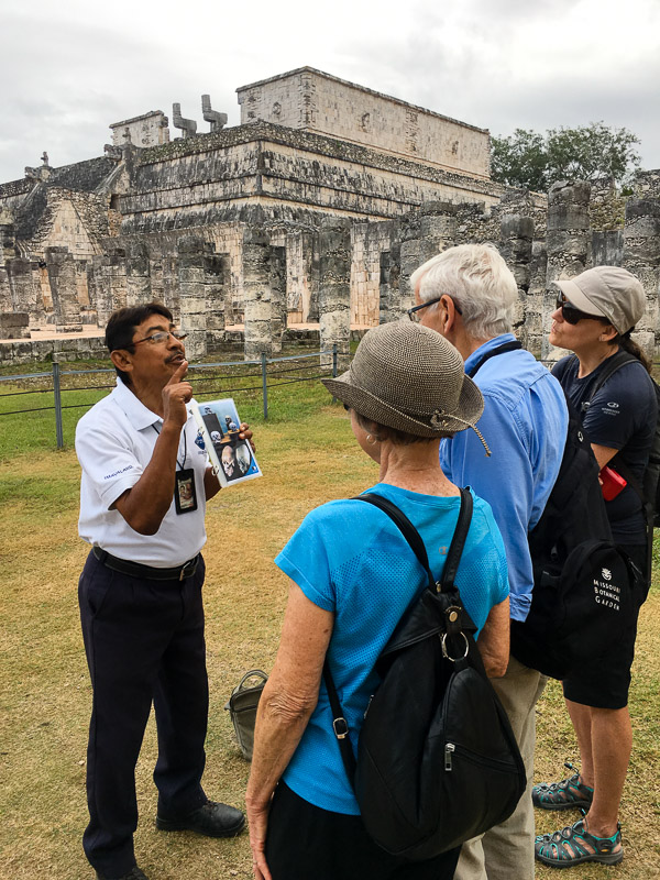
The next day we went to the Maya ruins of Chichén Itzá. Kristina and Patty are inside the gate to the city.

We hired a guide to tell us about Maya history. Victor was Maya, and spoke Maya, Spanish and English.
Behind us is an old covered market area with some of the 1,000 columns that supported the roof (that was likely made of wood and thatch and disintegrated long ago).

The Pyramid of Kukulcan demonstrates how advanced the Mayas were. The dimensions of the pyramid represent the 365 day solar calendar, with 91 steps on each of the four sides representing the amount of time between solstices.

One of the staircases has two Kukulcans, serpent-gods, at the bottom. The pyramid’s position reflects Maya knowledge of magnetic north, and on the vernal and autumnal equinoxes the pyramid casts shadows such that the body of the serpent appears as light coming down from the top of the pyramid.

The Pyramid of Kukulcan is 24 meters tall. It was beautifully restored early in the 20th century, and since 2007 people are no longer allowed to climb it.

This temple complex at Chichén Itzá had smaller buildings with elaborate friezes. There were many carvings of Chaac, the god of rain. Rain was essential for Maya agriculture.


Kristina and Patty are in front of a striking temple with a central carving of Kukulcan with corn plants around his head.

Here’s a closer look.

And here’s a view of the three temples in the complex.

Nearby this building is being restored. The workers are removing plants that were growing through every nook and cranny.

Then we walked to the Sacred Cenote, and learned that it hadn’t been used for drinking water. Instead offerings to Chaac the rain god were made by throwing gold, jade and obsidian into the well.

The Maya were advanced astronomers too. Even though they didn’t have telescopes, they plotted the orbit of Venus with its 584 day cycle, and they accurately predicted solar eclipses 500 years in the future. The Observatory is the only round building in Chichén Itzá, and its upper windows are aligned with the annual sun cycle.

But science didn’t save the Maya, who were subjugated by the Toltec starting in the 10th century. The Toltec were warriors who had rituals of human sacrifice to appease their gods. This wall of skulls is thought to be a memorial to the sacrificial victims, and includes about 1,000 carvings of skulls.

This is a chac mool, sacrificial altar, that the Toltec used to offer the still-beating heart of the sacrifice victim to the gods.

We learned so much and were so impressed by the Maya. Here’s a shot of the Observatory with a full moon overhead.

Just 30 minutes away from Chichén Itzá was a cenote that allowed swimming. When we arrived we walked around their beautiful grounds.

Here’s a view of the Yokdzonot Cenote from above. Cenotes are created when there is a lot of limestone in the bedrock. A cavern is formed by underground water, and when the cave roof collapses, a cenote results.

By the time we jumped into the water, we had it all to ourselves.

Kristina brought her snorkel and mask, and she was happy to see four types of fresh water fish in the cenote. Bill was happy to have a life jacket.


Called the Yellow City because of all the yellow painted buildings, we enjoyed walking around the town.


Here is the front of restaurant Kinich Izamal where we went for lunch.

The restaurant served traditional foods of the Yucatán, and Pete ordered dzic de venado, slow cooked venison.

Then we drove to Mérida, the capital of the Yucatán. We stayed near the old town, so we could walk around there.

This is the Mérida Cathedral.

The following day we drove to Uxmal to visit older Maya ruins that had their heyday in the 7th and 9th centuries. This is the Temple of the Magician.

Patty is in front of the decorated side of the Temple of the Magician.

And here’s from temple another vantage point. Standing 49 meters high, it’s 7 meters taller than the Pyramid of Kukulcan at Chichén Itzá.

We were allowed to climb the Great Pyramid, which has only been restored on one side. Patty is up top on the left, waving.

At the top we saw the Temple of Macaws, with carvings of the birds.

This was the view from the top of the Great Pyramid.

This building is called the Governor’s Palace and it was probably a residence. In front is a two-headed jaguar throne.

These stairs were fewer and easier to climb than the pyramid, so we headed up to check out the elaborate friezes.


There are 103 Chaac carvings on the Governor's Palace, showing the importance of rain to the Maya. There was a complex system of underground cisterns at Uxmal that were used for storing water during the dry season.

Here’s a closer look at several Chaac carvings.

The Temple of the Magician is clearly visible beyond Patty and the palace.

And here's the current Governor of Uxmal!

We were interested to look at photographs of the 2014 Governor’s Palace restoration project.

We were impressed to see how much manual labor and teamwork was required to rebuild it.

Pete is standing at the Governor's Palace. In the background on the left is a group of buildings called the North, South, East and West buildings that form a square.

This is the North building, which is the highest in the group so it likely had the most importance for Maya religious purposes.

Patty is climbing up to the North chapels for a closer look. There are several Chaac carvings to her right.

The last area we visited was the Cemetery. It gets its name from the carvings of skulls and bones, but likely it was a temple and not a cemetary.

Our final night in Mérida coincided with a festival. We were able to go into City Hall and see their incredible historical murals by Fernando Castro Pacheco.

Here’s a close up of the painting of Felipe Carrillo Puerto and Lázaro Cárdenas, who in the early 20th century helped emancipate the Maya people and returned land to them.
